
(NEW YORK) — A storm system closing in from the Atlantic Ocean is expected to become Tropical Storm Imelda by the end of this weekend, and could bring storm surges and high winds to the Southeast U.S. coastline early next week.
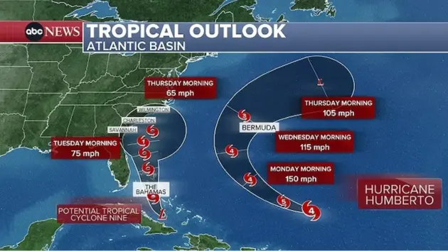
The National Hurricane Center said Saturday that the storm — currently officially known as Potential Tropical Cyclone Nine, or PTC Nine — was northwest of the eastern tip of Cuba as of 5 a.m. ET, moving northwest at around 7 mph and forecast to cross the central and northwestern Bahamas this weekend.
The storm is expected to approach the southeastern U.S. coast early next week. A tropical storm warning is in effect for the central and northwestern Bahamas.
PTC Nine is expected to develop into a tropical depression on Saturday and a tropical storm around Saturday night or early Sunday. When it becomes a tropical storm, it will take the name Imelda.
Rain associated with the storm is expected to impact eastern Cuba, Hispaniola, Jamaica and the Bahamas, with flash and urban flooding forecast through the weekend, the NHC said. Mudslides are possible in higher terrain, it added.
Expected rainfall is around 4 to 8 inches for the Bahamas, 8 to 12 inches and localized totals up to 16 inches for eastern Cuba, and 2 to 4 inches of additional rain for other parts of Cuba, as well as Jamaica and Hispaniola.
Up to 3 feet of storm surge is also expected for the coastlines in the northwestern Bahamas.
As the system approaches the U.S., coastal Georgia, the Carolinas and mid-Atlantic states may all see flash, urban and river flooding, the NHC said.
The storm is expected to be at or near Category 1 hurricane intensity when it approaches the U.S. coast early next week, the NHC said, bringing storm surge and wind.
Meanwhile, Hurricane Humberto has rapidly intensified to become the third major hurricane of the 2025 Atlantic hurricane season. The NHC said Saturday that Humberto is expected to “remain a powerful major hurricane through early next week.”
Humberto is still expected to track west of Bermuda on Tuesday through Wednesday and stay hundreds of miles west of the U.S., eventually turning northeast and back out to sea without a landfall.
Swells generated by the hurricane will begin affecting portions of the northern Leeward Islands, the Virgin Islands, Puerto Rico and Bermuda this weekend, the NHC said in its latest update.
Copyright © 2025, ABC Audio. All rights reserved.