
(NEW YORK) — A new winter storm is moving east on Monday, bringing dangerous wind, snow and ice to millions.
Wind gusts up to 45 mph are possible in Iowa, Illinois, Indiana, Ohio, Kentucky, West Virginia, Pennsylvania, New Jersey, Delaware and Maryland.
Gusts up to 65 mph are possible in Cleveland, Ohio, Michigan and parts of Pennsylvania, where high wind warnings are in effect.
A blizzard warning is in effect across parts of Iowa, Wisconsin and the upper peninsula of Michigan. Heavy snow and wind gusts up to 50 mph are creating whiteout conditions. Minneapolis was under a winter weather advisory Monday morning due to the blowing snow.
Marquette, Michigan, has reported a foot of snowfall, and parts of Minnesota already reported 6 inches as the snow continues to fall Monday morning.
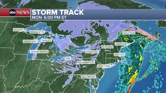
In Northeast, the main danger Monday morning is ice.
An ice storm warning is in effect from New York through much of Vermont, where 4 to 7 tenths of an inch of ice is possible. This amount of ice makes travel extremely dangerous and can down trees and powerlines.
By noon on Monday, the snow will be moving east, impacting Michigan, Ohio, western Pennsylvania and western New York.
Rain will be impacting Boston to Maine on Monday afternoon as the icing continues in upstate New York and Vermont.
By 6 p.m. Monday, the rain will be ending in Boston and the lake effect snow will kick off across northeast Ohio, northeast Pennsylvania and upstate New York.
That lake effect snow machine will continue through much of this week.
Places like Orchard Park, New York, outside of Buffalo, could see 1 to 3 feet of snow this week, and wind gusts up to 65 mph could create whiteout conditions at times.
Copyright © 2025, ABC Audio. All rights reserved.